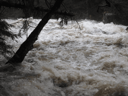
Photo by Scott Bailey
On October 27, 2017 two days before the remnants of Tropical Storm Philippe drenched New England, toppled trees, and cut power to over 1.1 million customers, a dozen scientists at the USDA Forest Service’s Hubbard Brook Experimental Forest (HBEF) in North Woodstock, NH were hard at work. Alerted by meteorologist Eric Kelsey (Director of Research at Mount Washington Observatory) of a potentially historic extreme rain event, they activated a “Water RAT,” or a Rapid Assessment Team, to monitor the pending storm.
They double checked digital weather and stream flow sensors, wireless communication devices, backup power generators, and deployed four automated water quality samplers, all to capture the unique physical and chemical signatures of the storm. Throughout the weekend, they communicated with each other by email and text message, and safely watched the storm unwind via their online digital data portals. As the storm cleared out on October 30, they had their storm data, and they began searching for clues to better understand the impact of this extreme weather event on the quantity and quality of water spilling out of upland forests into Hubbard Brook, which flows into the Pemigewasset River, the Merrimack River and ultimately the Atlantic Ocean. By having a better grasp of detailed processes occurring in small headwater streams before, during, and after storm events, scientists will gain a better understanding of connections between extreme weather events and landscapes, and ultimately be better poised to predict the consequences of extreme weather events on water quality, and the magnitude and timing of flooding on larger streams and rivers and the communities they support.
Their results showed that the ~8,000-acre valley that forms the Hubbard Brook Experimental Forest received between 3.4 inches (Rain Gage 1) to upwards of 5.3 inches (Rain Gage 14) of rain over a 31-hour period, with rainfall intensities as high as 0.22 inches per 15 minutes (Rain Gage 14). Although this was a large rain event, it ranked only #25 in 60 years of record keeping at the Hubbard Brook Experimental Forest. By comparison, the biggest rainfall event on record at Hubbard Brook was a 6.8-inch event occurring over a 57-hour period from June 28-30, 1973. Wind speeds during the recent storm, recorded at Mount Kineo overlooking the Hubbard Brook valley, peaked at ~40 mph, well below the 110 mph gusts buffeting Mount Washington, 50 miles to the northeast, and below the maximum gusts recorded at this site of 58 mph, recorded on February 17, 2013 (records only go back to August 2012). Wind directions remained largely from the southeast, showing that this storm was a “Sou’easter” as opposed to the “Nor’easters” that typically spawn heavy rain and wind in the New England. A small gaged upland stream in the valley, named simply “Watershed 3,” reached a peak flow of 25.3 cubic feet per second (cfs). The flow was high relative to the stream average of 0.6 cfs, but ranked only #24 in the largest peak stream flow for the 60 year record. In contrast, the largest recorded flow for this stream—64.5 cfs—occurred early on in the Hubbard Brook Experimental Forest record on October 24, 1959, in the middle of a prolonged, several day, drenching rain event.
But that’s not the whole story. The October 29-30, 2017 storm came on the heels of another, even larger rain event that occurred over a ~55 hour period from 6:00 am on October 24, 2017 to 5:30 pm on October 26, 2017 at the Hubbard Brook Experimental Forest. This earlier storm dropped 5.1 inches of rain at mid elevations on the Hubbard Valley with maximum rain fall intensity of 0.44 inches per 15 min. Water from this storm wet the soils, recharged groundwater, and rejuvenated the streams that had been running at baseflow conditions after a long, dry, and unseasonably warm autumn. Wind speeds reached ~34 mph at the Mount Kineo recorder, largely from the southeast direction. Streamflow for the earlier storm peaked at just 5.2 cfs at Watershed 3; a much lower peak flow despite it being a larger rain event with greater rainfall intensities, which resulted in part from the greater amount of rain adsorbed by drier soils and recharging ground water. This October 22-26 storm, which replenished soil water and groundwater, helped to set the stage for the rapid movement of water from atmosphere to streams and the higher streamflows that occurred during the smaller October 29-30 storm that followed.
The meticulous work of the Hubbard Brook scientists during these two October storms, and over the past 60 years, highlights two points. The first is that small portions of the landscape, like the Hubbard Brook Experimental Forest, are not always representative of regional hydrology and that measures of absolute rainfall amounts or streamflows from these locations should be extrapolated with care. What makes extreme weather events like the recent remnants of Tropical Storm Philippe, Tropical Storm Irene in 2011, the Ice Storm of 1998, the hurricane of 1938 and others significant are both their intensity and their scale, impacting large swaths of the region, including complex spatial and temporal variability, and affecting millions of people. Second, the true merit of the work done at long term research sites like the Hubbard Brook Experimental Forest is in understanding the processes that create extreme hydrological and biogeochemical events, and transferring the knowledge of these processes to larger river basins and landscapes.
With the deployment of a new generation of environmental sensors and wireless communications, scientists at USDA Experimental Forests are creating Smart Forests that harness the power of digital data capture and delivery, allowing scientists to safely track storms in near real time, and ultimately speeding up the pace and scope of scientific discoveries. Scientists at the Hubbard Brook Experimental Forest successfully completed the October 2017 Water RAT and are watchfully waiting to capture their next big water, wind, snow or ice RAT.
Hubbard Brook Water Rapid Assessment Team:
Scott Bailey (USDA Forest Service)
Amey Bailey ((USDA Forest Service)
Frank Bowles (Research Designs)
John Campbell (USDA Forest Service)
Mark Green (Plymouth State University)
Ian Halm (USDA Forest Service)
Eric Kelsey (Plymouth State University and Mount Washington Observatory)
Mary Martin (University of New Hampshire)
Lindsey Rustad (USDA Forest Service)
Hannah Vollmer (Hubbard Brook Research Foundation)
Tammy Wooster (Cary Institute of Ecosystem Studies)
Geoff Wilson (Cary Institute of Ecosystem Studies)